


1. Overview of Ba Den Mountain
Ba Den Mountain is located in Binh Minh ward, Tay Ninh city, about 7 km northwest of Tay Ninh center and only 90 km to 110 km from Ho Chi Minh City via National Highway 22. It is the highest mountain in the Southern Vietnam region with a height of 986 m, belonging to a group of three mountains including Ba Den, Phung, and Heo, with a total mountain area of about 24 km². A notable feature is the extinct volcano located in the middle of the Southeastern Vietnam plain, possessing a diverse ecosystem and a pleasant climate year-round.
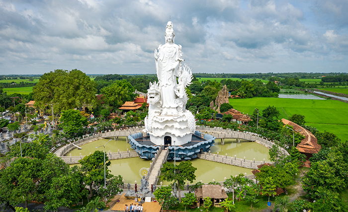
Recognized as a national historical and scenic site since 1989, Ba Den Mountain welcomes millions of tourists annually thanks to its unique spiritual tourism routes with a chain of pagodas and temples, along with major festivals such as Via Ba Linh Son. Additionally, it is an ideal destination for those who love cloud hunting, trekking on modern mountain trails, and experiencing cable cars through the forest. The most prominent feature is the Tay Bo Da Son Lady Buddha statue, 72 m high, the largest Lady Buddha statue in Southeast Asia, and rare natural gardens.
With its vast area and diverse terrain, the Ba Den Mountain map is a powerful tool for tourists to plan a reasonable itinerary and determine the correct route. During festivals or peak times, using a digitized map helps tourists quickly identify routes, proactively search for services and attractions without missing any experience.
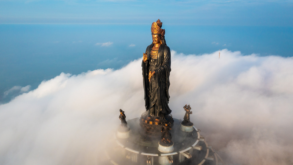
The sacred Statue of the Goddess of Mercy Tay Bo Da Son on the summit of Ba Den Mountain. (Source: Collected)
2. Introduction to the Ba Den Mountain Map
2.1. Overall Map of Ba Den Mountain Tourist Area
The current overall map is intuitively designed from the tourist area entrance, parking area, service center, cable car station system, to the entertainment areas and exploration trails. Information on the Ba Den Mountain map is always updated regularly with many versions, from online ones, printed copies distributed at service counters, to illustrated diagrams at each important area.
Parking lots are arranged reasonably for both cars and motorbikes, convenient for parking and then moving into the tourist area center. The service center area gathers ticket counters, souvenir shops, food courts, and stalls serving food and drinks, meeting the basic needs of tourists. The cable car station system includes Ba Den station at the foot of the mountain, Chua Hang station halfway up the mountain, and Van Son station at the summit, serving as the starting point for various sightseeing routes.
The pagoda area concentrates famous pagodas and temples, attracting many pilgrims. The outdoor entertainment area includes games suitable for all ages, along with a square area and an outdoor stage for special art programs.
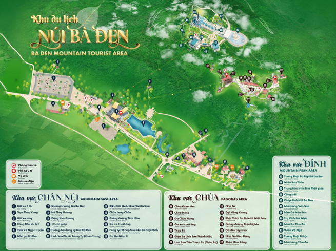
Map describing the areas and attractions at Ba Den Mountain. (Source: Collected)
2.2. Zoning of attractions and recreational areas on the map
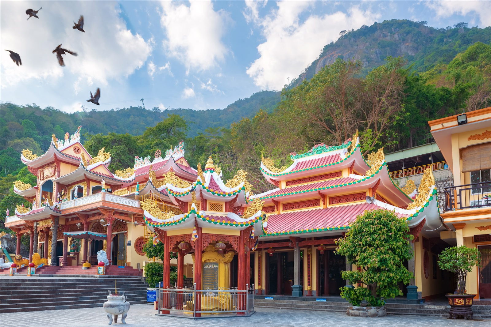
Ba Pagoda (Linh Son Tien Thach Tu) is an important spiritual center of Ba Den Mountain, where the sacred Lady Buddha Quan Am is worshipped. Cave Pagoda is located on the mountainside, impressing with its architecture formed within a natural cave. Ma Thien Lanh Valley stands out with its pristine beauty, serving as an ideal setting for nature photography and a connection point for many captivating trekking routes.
The Mountain Peak - Sky Gate is where the majestic Lady Buddha Tay Bo Da Son statue is placed; from here, one can admire the vast panoramic view of Tay Ninh. Prominent check-in spots are reasonably arranged at the foot of the mountain, the square, Van Son station, along with many flower gardens and miniature landscapes, contributing to creating vibrant frames.
The map of Ba Den Mountain is divided into three main areas. The foot-of-mountain area includes a parking lot, entrance gate, square, cable car station, and other facilities. The pagoda area concentrates pagodas such as Quan Am Pagoda, Cave Pagoda, Linh Son Tien Thach Tu, along with pilgrimage paths. The mountain peak area includes the Sky Gate, the Lady Buddha statue, a viewing deck, and ideal spots for cloud hunting activities. Thoroughly understanding the map helps visitors arrange a reasonable itinerary, avoid getting lost, and save significant travel time.
Understanding the map will help visitors reach their desired destinations. (Source: Collected)
3. Effective Use Guide for Ba Den Mountain Map
When using the Ba Den Mountain map , visitors should pay attention to important explanatory icons. Spiritual sites are often symbolized by a fire icon or a Buddha image, service areas are represented by restaurant icons and drink counters, entertainment games are shown by palm tree or balloon icons. Facilities such as restrooms and medical stations are represented by easily recognizable red cross icons.
Choosing the right type of map plays an important role in the sightseeing experience. It is advisable to prioritize the Ba Den Mountain map electronic version on the official website or via the phone application to get updated directions and easily look up routes while moving. Online maps have the advantage of allowing flexible zooming in and out, and have a GPS positioning function to accurately determine your location.
4. Other Tourist Attractions in Tay Ninh
4.1. Dau Tieng Lake
Dau Tieng Lake is one of the largest artificial lakes in Southeast Asia, with a water surface area of up to 270 km². This place impresses with its peaceful scenery, very suitable for camping, picnicking, and cycling around the lake. Visitors can enjoy the moment of a brilliant sunset reflected on the clear blue lake.

Sunset scene at Dau Tieng Lake. (Source: Collected)
4.2. Ma Thien Lanh
Ma Thien Lanh Valley lies between three mountains, serving as a convergence point for cool streams and primary forests. This is an attractive destination for those who love trekking, cloud hunting, and photography amidst vast nature.
Ma Thien Lanh brings visitors a feeling of immersion in nature. (Source: Collected)
4.3. Cao Dai Holy See
The Cao Dai Holy See is the largest religious center in Tay Ninh, with distinctive architecture blending diverse cultural elements. This is a place to experience the unique religious cultural beauty of Nam Bo, highlighted by solemn and meaningful worship rituals.
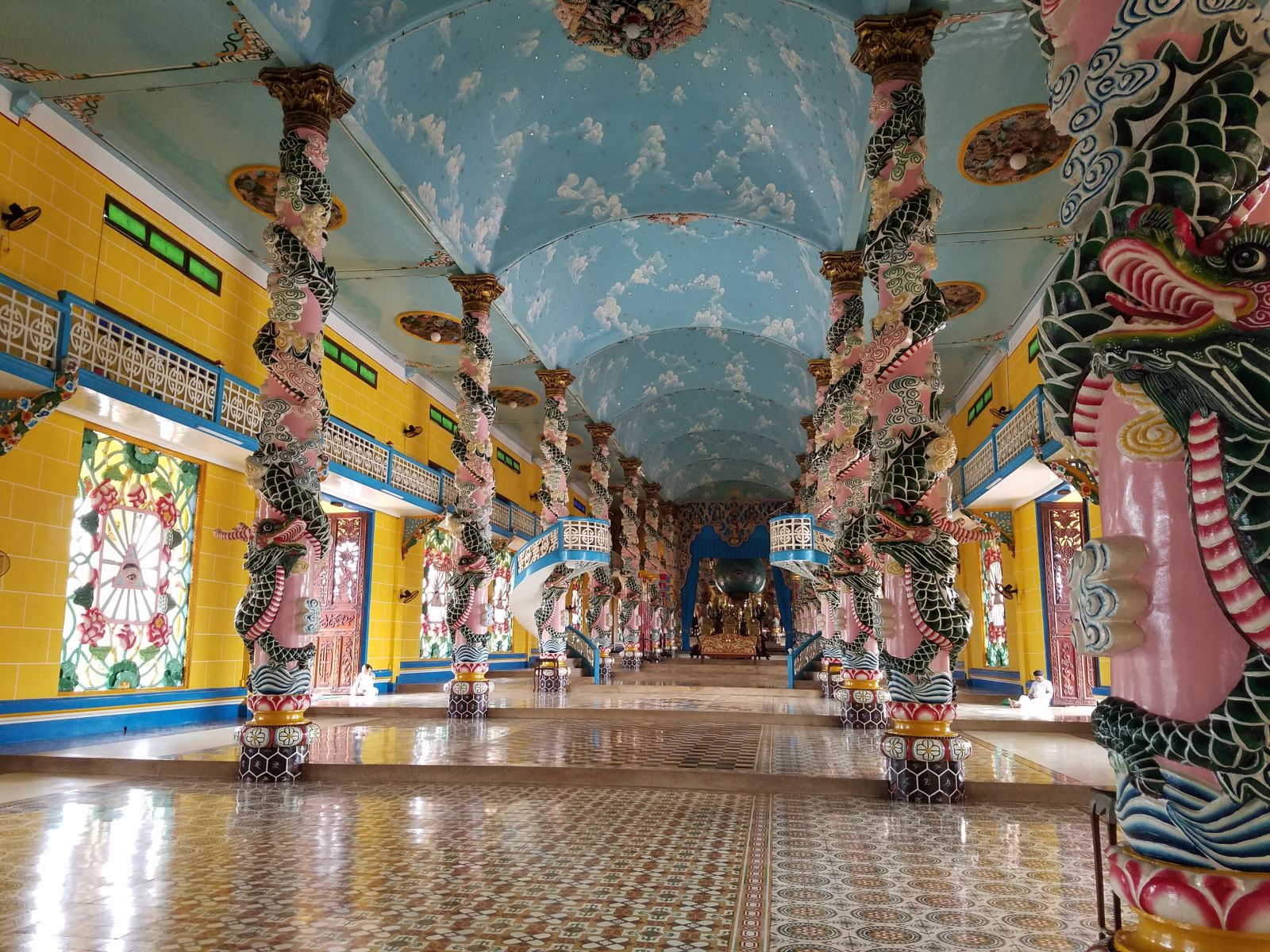
The space inside Cao Dai Holy See. (Source: Collection)
4.4. Chang Riec Forest
Chang Riec Forest, located in Tan Bien district, is a primeval forest that still retains its original wildness. This is a suitable destination for trekking activities, learning about the forest ecosystem, and exploring revolutionary historical relics preserved to this day.
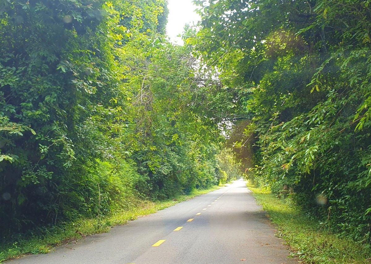
Main path in Chang Riec forest. (Source: Collected)
4.5. Thien Lam Go Ken Pagoda
Thien Lam Go Ken Pagoda is an ancient pagoda with unique Southern Buddhist architecture. Located amidst lush green rice fields, the pagoda offers a peaceful and serene space in the heart of Tay Ninh.
Chua Thien Lam Go Ken attracts many pilgrims every year. (Source: Collected)
5. Experience and tips for using the Nui Ba Den map accurately and safely
When using the Nui Ba Den map, safety is always the top priority. Visitors should follow the planned routes, not arbitrarily cross the forest or enter paths not on the official map. Especially for children or the elderly, always stay close together along the marked routes and pay attention to weather announcements and the latest regulations at the tourist area.
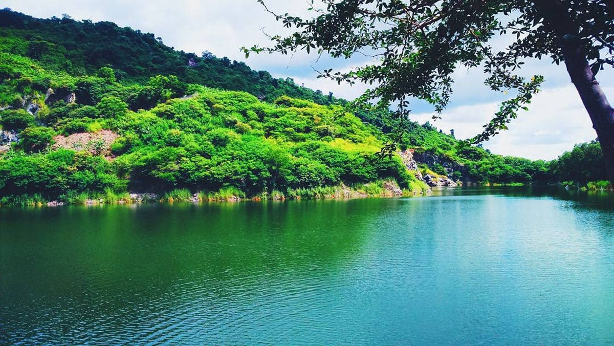
Integrating GPS technology and Google Maps with the Nui Ba Den map will help accurately determine location, minimizing the possibility of getting lost, especially when exploring quiet areas. Beautiful scenic spots on the map include the observatory on the mountaintop, the viewing deck near the Lady Buddha statue, flower gardens at the foot of the mountain, and independent check-in points in Ma Thien Lanh valley.
To capture beautiful photos while ensuring privacy, choose spots on the mountainside, near Thuy Duong lake, or the sky gate in the early morning or late afternoon. It is advisable to avoid major pagodas during peak hours and prioritize side routes and new check-in points updated on the Nui Ba Den map in 2025 to experience a quiet space and leave many impressions.
The Nui Ba Den map is not only a tool to support navigation but also a key to fully explore the interesting things on this sacred mountain. Prepare well with knowledge and map reading skills to make your journey safe and complete!