




1. Overview of Fansipan Map and Sun World Fansipan Legend Tourist Area
1.1. Where is Fansipan and what's special about it?
Located in the Hoang Lien Son mountain range, Fansipan is the highest mountain in Vietnam with a height of 3,143 m, also known as the “Roof of Indochina”. For a long time, it has become an iconic destination in the central Sapa area, attracting tourists with its majestic mountain scenery and diverse ecosystem.
Fansipan also stands out with its combination of nature and cultural – spiritual values. On the journey to conquer the summit, visitors can encounter a large-scale spiritual architectural complex with works such as the Great Buddha Statue of Amitabha, Kim Son Bao Thang Pagoda, or the Arhat path system. These structures are built harmoniously amidst the mountain and forest space, creating an experience that is both exploratory and spiritually profound.
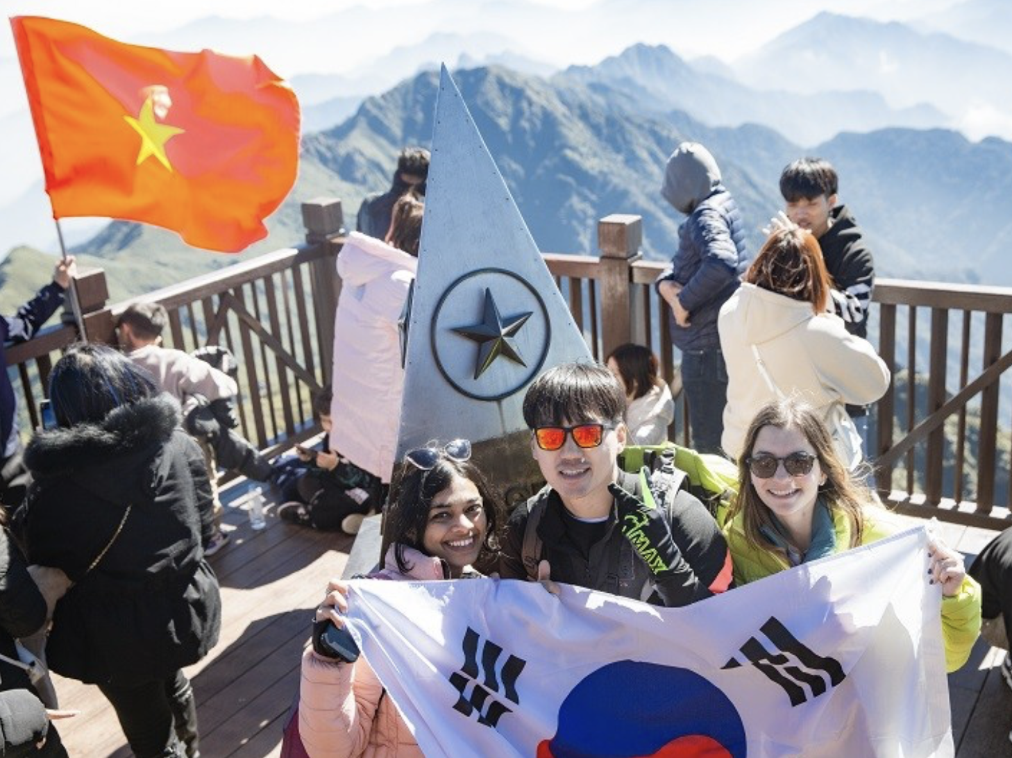
Fansipan is the highest mountain in Vietnam with a height of 3,143 m, attracting many domestic and international tourists. (Source: Collected)
Today, thanks to the modern cable car system at Sun World Fansipan Legend, conquering Fansipan has become easier, opening up experiential opportunities for many types of tourists instead of just professional trekkers as before. Tourists can book tickets online in advance on the official website of Sun World Fansipan Legend.
1.2. Overall map of Fansipan tourist area
To clearly understand the journey to explore Fansipan, it is essential to grasp the Fansipan map. The entire Sun World Fansipan Legend tourist area is designed along an experience axis stretching along the altitude, starting from the center of Sa Pa and ending at the Fansipan peak.
The journey usually begins at the Sun Plaza area – where the Muong Hoa mountain climbing train station is located. From here, tourists travel through Muong Hoa valley to the cable car station. Next is the cable car segment that takes tourists up to the Fansipan station at an altitude of nearly 3,000 m, where the main sightseeing activities begin.
From the cable car station, the tourist area map continues to expand with many different experiential zones. Tourists can choose to walk through stone steps or use the mountain climbing train to reach the summit area. Along the way is a complex of spiritual architecture with many prominent structures, arranged in layers along the mountainside.
The end point of the journey is the 3,143 m milestone – marking the Fansipan peak. Overall, the Fansipan map is not just a simple travel map but also clearly shows the experiential structure by stages, helping tourists easily visualize and proactively plan their exploration according to their time and physical strength.
2. Map of the journey to conquer Fansipan from A–Z
2.1. Stage 1: From Sa Pa center → Muong Hoa Train Station (Sun Plaza)
The journey according to the Fansipan map starts from the central area of Sa Pa, where hotels, restaurants, and main attractions are concentrated. This is also the most convenient starting point to travel to Sun World Fansipan Legend tourist area.
The starting point of the journey is the Sun Plaza building – a prominent European-style architectural work, and also the location of the Muong Hoa mountain climbing train station. From the center of Sa Pa, tourists can easily get here by walking, taxi, or motorbike taxi, taking about 10–15 minutes.
At Sun Plaza, tourists will choose their mode of transport to continue their journey. The most popular is the Muong Hoa mountain climbing train, which connects directly to the cable car station area. Additionally, if you want flexibility in time, you can also travel by taxi directly to the cable car station by road. However, the train experience is still chosen by many due to its convenience and impressive scenery along the way.
2.2. Stage 2: Muong Hoa Mountain Climbing Train → Hoang Lien Station
After departing from Sun Plaza, the next stage in the Fansipan map is to travel by the Muong Hoa mountain climbing train. The train line is about 2 km long, taking tourists across Muong Hoa valley, one of the most characteristic scenic areas in Sa Pa.
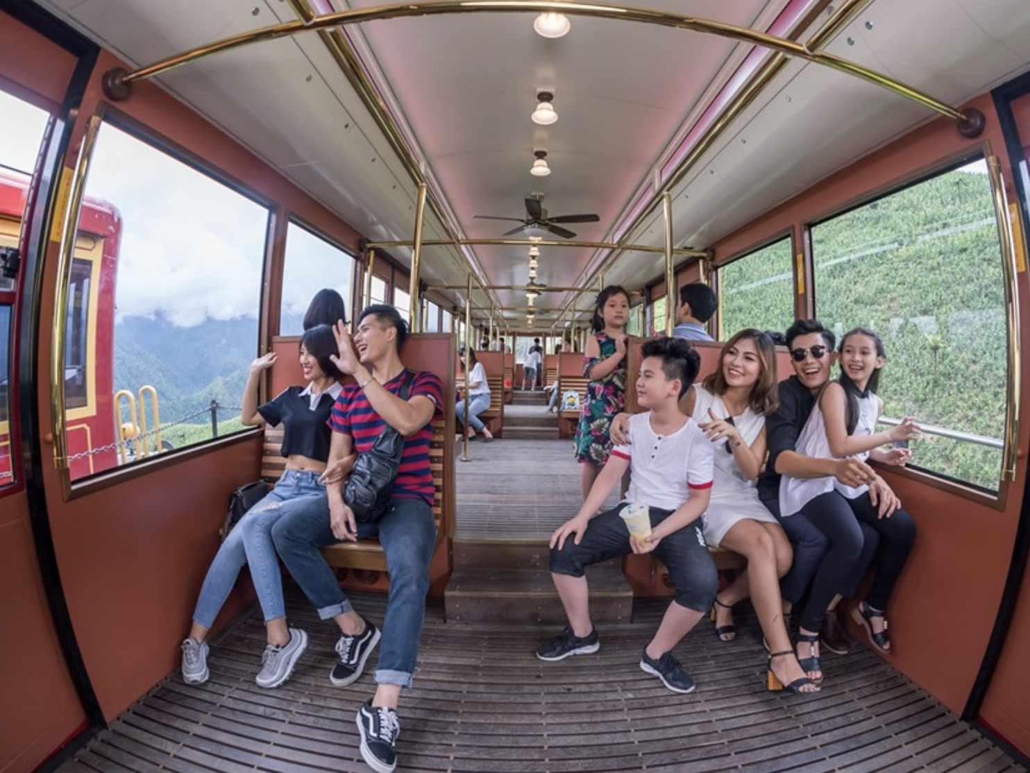
From the train window, visitors can admire the terraced fields, villages, and the vast Hoang Lien Son mountain range. (Source: Collected)
The travel time is only about 4-6 minutes, but this is one of the notable experiences of the journey. From the train window, visitors can admire the terraced fields, villages, and the Hoang Lien Son mountain range stretching before their eyes. The interior space of the train carriage is designed in a classic European style, creating a comfortable feeling throughout the short journey.
The train route ends at Hoang Lien station - an important transfer point, directly connecting to the Fansipan cable car system. Here, visitors will continue their journey upwards by cable car to get closer to Fansipan peak.
2.3. Stage 3: Fansipan Cable Car → Fansipan Station
Continuing the journey in the Fansipan map, from Hoang Lien station, visitors will enter the most important stage: the Fansipan cable car experience. This is a modern three-rope cable car line, approximately 6,292.5 meters long, taking visitors from the foot of the mountain to the Fansipan station area at an altitude of nearly 2,800 meters.
The travel time is about 15-20 minutes, enough for visitors to admire the majestic natural scenery of the Hoang Lien Son mountain range from above. Through the cabin glass, the landscape unfolds with Muong Hoa valley, primeval forests, and the characteristic sea of clouds of the Northwest mountains. This is also one of the most outstanding experiences in the entire journey.
The arrival station is designed with a combination of Asian-European architecture, nestled amidst the mountainous landscape, serving as an important stop before continuing the journey to Fansipan peak.
2.4. Stage 4: From the Station to Fansipan Peak
After leaving the cable car cabin, the final journey in the Fansipan map is to travel from Fansipan station to the peak at an altitude of 3,143 meters. From here, visitors have two options depending on their physical condition and desired experience.
The popular option is to walk up about 600 stone steps, taking 10-15 minutes. Along the way, visitors can combine visits to spiritual architectural complexes such as the Great Buddha Statue of Amitabha, Kim Son Bao Thang Pagoda, or the Arhat statues, creating a journey that is both exploratory and cultural-spiritual.
Alternatively, visitors can use the Fansipan mountain climbing train to shorten the travel distance. This train line allows closer access to the peak, especially suitable for the elderly, young children, or in unfavorable weather conditions.
The end point of the journey is the 3,143-meter milestone – marking the summit of Fansipan. From here, visitors can gaze at the panoramic view of the overlapping mountains and the sea of clouds, completing the conquest journey according to the Fansipan map in a fulfilling way.
3. Map of Notable Attractions on Fansipan
3.1. Cable Car Station Area and Flower Valley
In the Fansipan map, the cable car station area is one of the first stops and also a place where many prominent attractions are concentrated. Before embarking on the journey to conquer Fansipan peak, visitors will pass through the flower valley area – which is likened to the "scenic gateway" of the entire tourist area.

Visitors can encounter vibrant flower carpets and especially a large-scale rose garden. (Source: Collected)
Fansipan Flower Valley impresses with its vast area, gathering many seasonal characteristic flower species. Here, visitors can encounter vibrant flower carpets, themed gardens, and especially a large-scale rose garden with hundreds of different flower varieties. The space is harmoniously arranged according to the mountain slope terrain, creating many check-in spots suitable for photography and resting.
Besides, the area near the cable car station has also been invested with miniature landscapes, pathways, and scenic spots overlooking Muong Hoa Valley. This is a place where visitors can relax and prepare for their next journey before boarding the cable car cabin.
Looking at the overall Fansipan map, the cable car station area and the flower valley serve as important transit points, as well as a gentle experiential space, helping visitors acclimate to the altitude and enjoy the scenery before embarking on the journey to the summit.
3.2. Spiritual Complex on Fansipan Mountain
In the Fansipan map, the spiritual complex area stretches from an altitude of about 2,900 m to near the summit, serving as one of the crucial highlights of the entire journey. The structures here are built in ancient Vietnamese Buddhist architectural style, blending with the mountain and forest landscape, creating a serene space amidst clouds and sky.
The most prominent is the 21.5 m tall bronze Amitabha Buddha statue, majestically located in a vast space. This is one of Fansipan's characteristic symbols, attracting visitors to stop for worship and photography. Besides, Bich Van Zen Monastery and Kim Son Bao Thang Pagoda are structures bearing strong imprints of traditional architecture, creating a stopover with clear cultural and spiritual value.
Along the journey, visitors will pass through the Arhat path with meticulously crafted statues, symbolizing Buddhist values. The entire area is arranged in layers on the mountainside, contributing to a journey of both exploration and contemplation within the overall Fansipan map.
3.3. Fansipan Summit and the 3,143m Milestone
The final point on the Fansipan map is the mountain summit area – where the 3,143 m milestone is located, marking the "Roof of Indochina." This is an iconic destination that most visitors aim for when starting their journey.
Here, visitors can take check-in photos next to the milestone, an important marker recording the moment of conquering Vietnam's highest peak. The summit area typically has low temperatures, is windy, and often covered by clouds, creating Fansipan's characteristic scenery.
From this vantage point, the view expands across the entire Hoang Lien Son mountain range with its overlapping layers of mountains and deep valleys below. In favorable weather conditions, visitors can observe an expansive sea of clouds, offering an impressive visual experience. This also marks the end of the exploration journey according to the Fansipan map, combining elements of conquest, scenery, and personal emotion.
3.4. Ban May and the Cultural Experience Area
In the Fansipan map, Ban May is the area located at the foot of the mountain, near the cable car station, serving as a connecting space between natural experiences and local culture. This is a suitable stop for visitors to explore the life of ethnic groups in the highlands before or after their journey to the summit.

Ban May is located at the foot of the mountain - a space connecting visitors between nature experiences and local culture. (Source: Collected)
Ban May is built like a miniature village, recreating the living space of many ethnic groups in the Northwest such as HMong, Dao, Tay, Giay, Xa Pho. Traditional wooden houses, ethnic costumes, and handicraft activities are clearly restored, helping visitors easily visualize the local cultural life.
Here, visitors can participate in many experiential activities such as watching folk art performances, enjoying traditional melodies, or learning about handicraft professions such as weaving and indigo dyeing. Besides, the culinary area offers characteristic dishes of the Northwest region such as com lam (bamboo-tube sticky rice), grilled meat, and corn wine, creating a diverse experience in both culture and cuisine.
Within the overall Fansipan map, Ban May is not only a tourist attraction but also a place that makes the journey more complete, as visitors have the opportunity to get closer to the cultural identity of the Northwest mountainous region.
4. Important Notes When Visiting According to the Fansipan Map
4.1. Travel Time and Queuing
When visiting according to the Fansipan map, proactively managing time is crucial for a smoother journey. Visitors should prioritize departing in the morning, especially around 8:00 AM, which is quite suitable for those who want the most time to experience.
The morning is also the ideal time to hunt for clouds and get the clearest views from the Fansipan peak. If you go later, the chances of long queues or encountering foggy weather will be higher, affecting the overall experience.
In addition, each leg of the journey, such as the train, cable car, or ascent to the summit, requires a certain amount of time. Allocating time reasonably between attractions will help you avoid rushing and ensure you have enough time to experience areas like the spiritual complex or Ban May.
4.2. Preparation Before Going to Fansipan
To ensure a convenient journey according to the Fansipan map, visitors should prepare well in terms of clothing and health. Due to the high mountain terrain, the temperature on Fansipan is usually lower than in the central Sa Pa area, especially in the early morning or late afternoon.
Appropriate attire should include a warm jacket, a scarf, and sports shoes with good grip for safe movement on stone steps. On days with changing weather, visitors can also prepare a light raincoat to avoid getting wet.
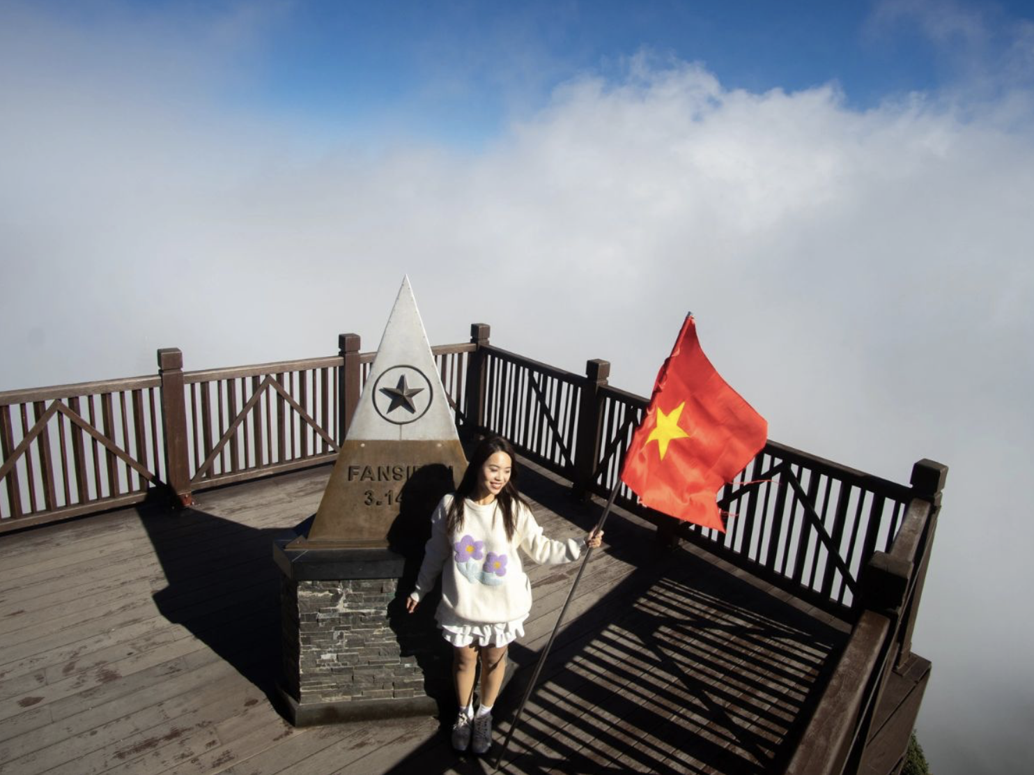
Visitors should pay attention to wearing warm enough clothes and sports shoes with good grip for safe movement. (Source: Collected)
In addition, you should bring personal drinking water and some light snacks to replenish energy during the journey. Although the journey is supported by cable car and mountain train, visitors still need to walk in some sections, so ensuring good physical condition will make the trip more comfortable. Adequate preparation beforehand will help you be more proactive throughout the journey and fully enjoy the experience of exploring Fansipan.
4.3. Tips for a complete experience at Sun World Fansipan Legend
To ensure the journey according to the Fansipan map is seamless and time-saving, visitors should prioritize booking tickets online before departure on the official website. Booking tickets early not only helps limit queuing at the counter, especially on weekends or peak seasons, but also helps you proactively choose a suitable time slot for the entire journey.
In addition, choosing a combo package combining the Muong Hoa mountain train and the Fansipan cable car is the optimal option. These combo packages help connect directly between travel stages, reduce waiting time, and limit the need for extensive travel by road. This allows you to focus more on experiencing the scenery and visiting the outstanding attractions along the route.
Furthermore, checking the operating schedule of the cable car and train in advance will also help you arrange your itinerary more reasonably. Combining advance booking with choosing the right combo package will make the trip more convenient, economical, and complete when exploring the entire Fansipan Legend area.
Understanding the Fansipan map helps the journey to conquer the "Roof of Indochina" become more proactive and coherent. From the center of Sapa through each stage of the train, cable car to the peak of 3,143 m, each stop offers a unique experience of scenery, culture, and spirituality. By grasping the travel structure and choosing a suitable option, visitors can easily enjoy the trip to the fullest, while optimizing time and effort throughout the journey of exploring Fansipan.


